Home | Family Pictures | What's Tom up to? | Rogues Gallery | Climbing Pictures | Anne's Art | Vacation Photo Album | Website Links | Contact Me

Mt Sill to Mt Winchell and the Palisade glacier
picture of traverse

Palisades Traverse, September 7-10 2004

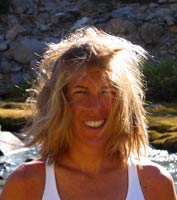
One afternoon I returned from climbing South Crack on the Stately Pleasure Dome and someone asked me if I wanted to do a traverse in the Palisades and then introduced herself as Kim. Well, I wasn't too busy, so I asked for some more information. It looked like a pretty big undertaking, but what's a little suffering? So I hastily threw some stuff together, and we headed off. Kim managed to convince Courtney to head along too. We stopped at the Mobil station for some food and then headed on down to Bishop.

In Bishop we stayed at the luxurious Thunderbird Inn. I took the first shower I'd had in 2 or so weeks, and sent my sun tan down the drain... We looked at the guidebook, the maps, and some accounts from others who tried this traverse. We decided that there was no way we could do it car to car in a day, and decided to hike in and bivy, then bust out the traverse and return. So that meant we didn't have a 3 am wake up. So we relaxed a bit and watched "black sheep" or something like that on the TV.
Innocents on in front of Temple Peak
picture of hikers
The next morning we went to the trailhead, packed up, and hiked in. Kim goes for adventure races and that sort of "entertainment" and she had been up the trail twice before. She set a blistering pace, but eventually she realized what she was doing and eased off to our relief. The trail wasn't too great for the first few miles, but then we went into some nice woods along a loud mouthed brook. The song for the day was "Bad boys" (the theme song for Cops, somehow we got talking about crystal meth heads in little towns like Big Pine and the subject of Cops in the Sierras came up...) Next up was a series of spectacularly blue glacial lakes and the impressive Temple crag.

The trail headed up and up gaining some 4,000 feet, and eventually turned into a less obvious climbers trail up onto the morraine above the Palisade glacier. (between 8 and 10 miles in) We found a good bivy site up there, and then headed off across the talus and morraines to scout our approach for the next morning. During this trip Courtney (smarter than the rest of us) decided that she wouldn't be able to maintain the pace required for the entire day and she didn't want to hold us back. Eventually I think I saw a route that would get us to the start of the traverse, and we headed back to pump some water and for some cool dinner (no stove) as the sun set and the temperature plummeted. Then it was time to try to sleep, with the alarm set for 2:30ish.

I didn't hear the alarm, but Kim was awake and she heard it, so we roused and got our
Kim silhouetted on the morraine
picture of kim
stuff together and headed off. The sub quarter waning moon was up to help us as we set off by headlamp. The talus seemed to go on forever. (I thought this was the talisade traverse, not the palisade). We were supposed to go around the glacier to the col between Winchell and Thunderbolt (the notch on the right with the fin in the picture of the traverse). The glacier was hard and slick and we traversed delicately on the rock above it and along the edge between the rock and the ice and up to the col where the wind was whipping through the notch. Luckily Kim had an extra pair of liner gloves which I wore for much of the day. We put on our harnesses and headed on up. Almost immediately we were on windswept 5th class climbing. I was motoring on up to try so stay warm. Kim wasn't nearly as comfortable on the same ground, so I set up a belay and brought her up a few tougher moves (maybe 5.6 or so with a lot of exposure). After that there was a lot more solid 4th class and very easy 5th class scrambling with a few brief sections of plain walking and a few that were more spicy. There was one notch we rapped down into. Then on and on up towards Thunderbolt. It looked like the traverse around the lightning rod would be very difficult, but the guidebook said pass it on the right, and it wasn't too bad after all. Then some weird and circuitous scrambling with a bit of 5th class and we were up below the summit block. This had a 5.9 bouldering problem that was pretty challenging in my approach shoes. Then I brought Kim on up. Thunderbolt peak, summit number one, 10:22 am, 14,003 feet. making good time, but there was a lot of rough terrain ahead, and a bit of cloud buildup to the south.

Looking down the west ridge from Thunderbolt
picture of w ridge
Looking towards Starlight peak from Thunderbolt
picture of starlight

On top of Starlight
picture of starlight summit
We headed on, looking across the next notch, it looked like more 5.10 terrain, certainly not what I wanted. But we had little choice at that point, following the guidebook's directions, we went down and right and only needed one straightforward rappel instead of the multiple odd ones that the other description had. The route finding was somewhat confusing and stressful, but my instincts mostly seemed to serve me well, and Kim kept up like a trooper, only needing a belay for sections with mid 5th class and up, especially those with massive exposure. Next up was the "coke bottle" summit of Starlight peak. I soloed up this one too, but Kim elected to stay below it. Starlight was the second peak, 1:31 pm, 14,200 feet. Not doing so good on the time anymore, but we were still moving. I think the altitude was getting to Kim more than it was to me, months at 7000 feet and then a few more weeks above 8,000 feet certainly helped a lot. Another sip of water, another "energy" bar, and keep on traversing. There really wasn't much time for resting all day.

Climbing up the flank of Palemonium
picture of palemonium

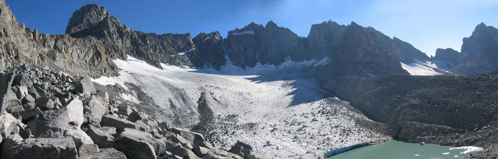
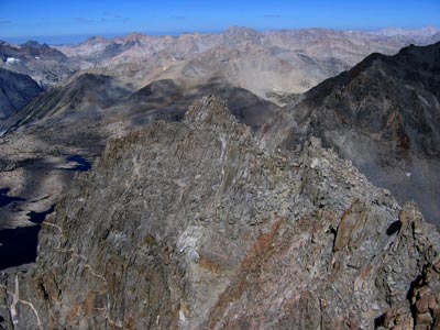
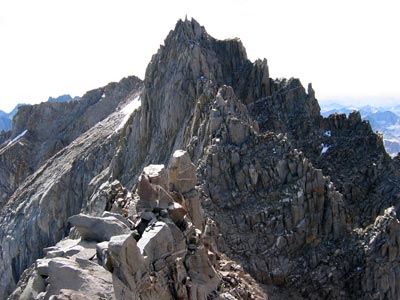
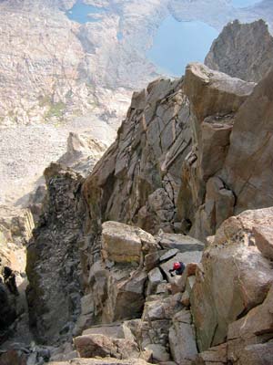
Next up was North Palisade, supposedly the most sought after summit in the sierras, 14,242 feet, and no easy way up. Certainly the way we went up didn't seem particularly easy, with one sketchy 5th class mantle the way I went up but eventually we got up there at 3:50. From there it was a short traverse to the "U" notch which we descended with 2 long rappels (25 M or so). Once again the way looked far too hard on the far side, but by traversing around to the right, we found a way that worked and we were up on what we called "Pandemonium" (Polemonium) 14,100 ft. 6:15, and time was running out. Luckily that was the end of the 5th class climbing as far as we knew. It was just a long scrambly ridgeline up to the summit of Mt. Sill, so off we went.

sunset from Mt. Sill showing some of traverse
picture of sunset

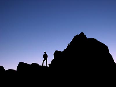
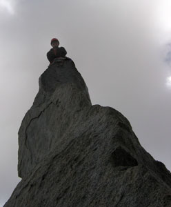
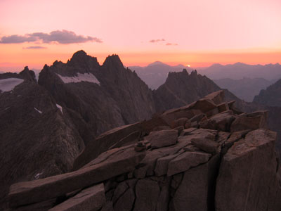
Scramble scramble scramble. I went on ahead and got up just at sunset, 7:15, 14,153 ft. After some pics, I put on my down jacket and hunkered down out of the wind to wait for Kim. She came up in a bit, and there was no more up. Just lots of descent in the dark. We put on our headlamps and started back down. I had spotted the place where the descent went over the NW flank of Sill, so we headed there. It seemed that the route dropped off precipitously, but there were plenty of holds. The long range route finding was difficult with only the LED headlamps, but we continued down ok. We missed a ledge that cut to the notch, but only had to climb up a little bit on very loose talus to get to the notch. Then it was down a long way on talus avoiding the hard snow and ice. Finally we turned the corner, and there was another couloir dropping off into the darkness at what seemed way to steep an angle. It was the only option, so down we went. Finally we got to the glacier, unfortunately, it was rock hard and steep. So once again we were skirting along the upper edge of a glacier. Unfortunately this one went on forever. At one point I dislodged a big rock that clattered on down the glacier alarming Kim, and at another I used a rock to cut steps across a tongue that I just didn't want to traverse up and over. Finally I hit the talus field. From there I made much better time, nearly running across the field of appliance sized blocks. A few shifted, but I was moving fast enough so that I was off them before they could get me. It went on forever. I got back to the bivy site at 10:35. I went back up to the top of the morraine so Kim could see my light, She got there about 11. Neither of us was psyched for the 8 to 10 miles back to the car, so we curled up under the sleeping bag that Courtney left and tried to sleep. It was much colder and windier than the previous night, but somehow I managed to sleep some of the time, I guess I was tired or something.

Hair by Palisades
picture of Kim

The next morning we packed up and slogged out to the car. Back through Bishop for e-mail, Mammoth for food and groceries, The Mobil to say hello to Courtney, and back up to Tuolumne Meadows to look at the photos and burn a disk of them. A successful adventure. Luckily, as Barry Blanchard says, "It doesn't have to be fun to be fun".

Here is what some others had to say about this area (with their pictures)
http://scotty.geostrachan.com/climbing/ca_peaks/n_pal/n_pal.htm


SummitPost pages: Thunderbolt Peak - Starlight Peak - North Palisade - Polemonium Peak - Mt. Sill