Home | Family Pictures | What's Tom up to? | Rogues Gallery | Climbing Pictures | Anne's Art | Vacation Photo Album | Website Links | Contact Me
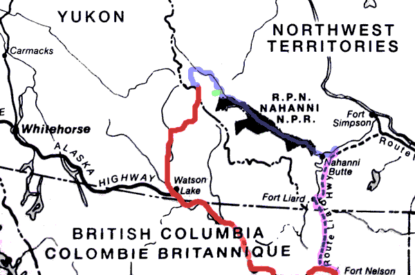
This is the story of our little adventure in Canada. We wanted to go to the Cirque of the Unclimbables, but didn't want to charter an airplane, so this is what happened... click here to zip down to a map at the bottom of the page. In case it looks all crazy on your computer, I made this on a computer with a 1028x768 screen running mozilla 1.7.7, so if it looks funny, sorry. Maybe eventually I'll get around to trying to make it look nice on other platforms.
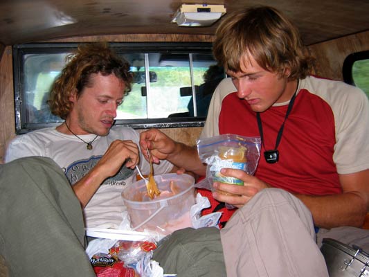
link to page of practicing for this tripIn the weeks leading up to departure everyone was getting the last bits of gear together and eating as much as possible to gain a few pounds. The food allotment for the trip was enough to survive, but not really enough to thrive with the kind of effort we expected to be expending. I think that we were getting 2000 calories a day, probably less than I eat normally just sitting around. I didn't have a scale, so I don't know how much I gained, but I do know that for the last week, I wasn't hungry at all, and kept stuffing vast amounts of heavy foods down my throat. I met up with some friends at Smith Rock and Tauna made it her mission to fatten me up. She was wildly successful, especially with the brownies - at least until I learned to clamp my lips shut to avoid yet another spoonful of crumbs.
| |
|---|
We met up in Seattle early in the morning of July 10th. I drove up from Portland that evening (leaving around midnight - tactical error). Andy and Jason drove from North Dakota and picked up Daniel at the airport in the wee hours. We packed everything into my nearly empty truck before dawn and headed North. We had no problems crossing the border at Sumas although the 2 who walked across in flip flops were told that hitchiking was illegal in Canada. Then up the Fraser River Valley. It was here we discovered another error. We didn't bring the ipod power cord. DOH. That left us with only 2 tapes I had thrown in at the last minute. More driving and swapping out positions (2 in the front, 2 in the back) brought us to Prince George around 7 pm. Craig was flying in at 10, so after failing to find bear spray, we went to a movie. Then on to pick up Craig and his stuff. That really packed the car a lot tighter and made riding in "the hole" a lot less pleasant. In fact, Craig referred to it as the "torture tube". Craig did bring 6 tapes of "Love Line", so we had the rants of Adam and Dr. Drew and a slew of misfit callers to help keep us awake. We continued north passing Fort Nelson early in the morning and crossing the 60th parallel into the Yukon and Watson lake in the afternoon. On the drive up we saw black and grizzly bears, bighorn sheep, bison, and moose. We tried to buy bear spray again, but had no luck. Instead we got a bunch of sandwich makings and 4 liters of ice cream. From there we were driving on a dirt road for some 100K before we turned off onto the Tungsten Range road which was fairly well maintained for the first 140 K or so, but then deteriorated for the last 60, especially after the turnoff to flat lakes. Still, we managed it with a 2wd truck with only one spot requiring scouting and one big bump that made those of us in the back flying (I hit my head and hip on the ceiling, but luckily had my hand over my head, so that saved me a bimp (Clouseau accent)). We passed through a storm and finally got as far as that road would take us around 9 pm. (the road was flooded by a Beaver Dam). We were glad to get out of the truck until we realized how thick the mosquitos were. On went the jackets and headnets (thank you very much OR, especially for the jackets which proved to be waterproof and bug proof - I wore mine every day, and all of many days). We had already finished off the ice cream with added peanut butter for increased calorie content and taste but there was still a lot of sorting and packing to do as well as sandwiches to eat. Twilight lasted until we were all in bed. In fact I think it lasted until dawn.
 |
|---|
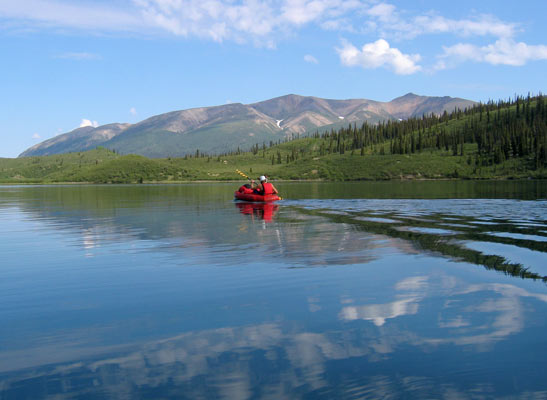
We packed up everything and strapped our rafts on top and hiked the kilometer or so to Flat Lake wading across the fledgeling Little Nahanni a few times. Then we inflated the rafts and strapped on our stuff and headed out down the lake. The water was crystal clear and shallow for some of the way, and soon we had passed through into another lake, then onto the Little Nahanni River. At this point the river was small and clear and flowing quickly through meandering loops. It was a delight to drift and paddle down, although one had to make an effort to avoid the shallow gravel bars. We saw a bald eagle and a number of fish. Eventually we came to where some rapids were marked on the map. We scouted the first bit, as we couldn't really see what was coming up, and this might have been the rapid that killed a solo kayaker a number of years back. There were a few more fun rapids after this one, and some more flatter water. Craig and Andy got surprised by a current heading around a bend into a strainer and got to swim. Finally we set up to camp on a sandbar and cooked dinner before the evening rainstorm hit. Craig caught some fish, we had made good time and distance this day, and things were going well even if we did have to retreat into a tent to eat dinner out of the rain. We couldn't find any trees with side branches strong enough to hang our food, so we strung a line around our camp with the cook pots hanging on it to alert us right before we got eaten by a grizzly. (there were a few tracks at the other end of the sandbar).
 |
|---|
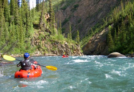
This day involved more fun paddling down a nice sized river. We ran a bunch of rapids in the first canyon. We could see far enough ahead to see somewhere to pull out, so we just ran things as they came without scouting. This really sped stuff up, but made for some hairy moments, and made it a lot harder to get good pictures. Things were going fine 'til there was a good horizon line. I let Andy talk me into just running it "very dangerous, you go first"... well, it was a drop of a few feet with a recirculation at the bottom stretching across the entire river. I tried to cut out of the worst of it, and flipped immediately. Everyone else flipped too, except Andy, who somehow (skill? bouncing off my head?) managed it cleanly. Luckily this was a short rapid, and I just swam through it with my boat before remounting. Craig and Jason both got banged up a bit while getting back in their boats. Then we saw some canoes on the bank. Turns out it was a Latvian-Canadian expedition with 2 canoes and a raft and 9 people. They had left Flat Lakes the 5th (we left the 12th!). We saw a web page listed in a register later--- Latvian site -- not so useful if you only read English, but a few pics and maps. We had been warned about Cascade Rapid being the worst of the Little Nahanni, and about 8k before the confluence with the South Nahanni, so as we approached that distance, we began to get cautious and look critically at every rapid rather than just running them as they came. After doing this for a while, we realized that we must have passed it. The weather was deteriorating and was seriously threatening by the time we got to the confluence that evening. The Little Nahanni had silted up a lot by then, but the S. Nahanni was a lot siltier. It started raining shortly after we set up the tents, and continued on and off for quite some time (well into the next day). Once we bailed to the tents, we decided to switch breakfast and dinner so we didn't have to cook that evening.
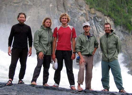
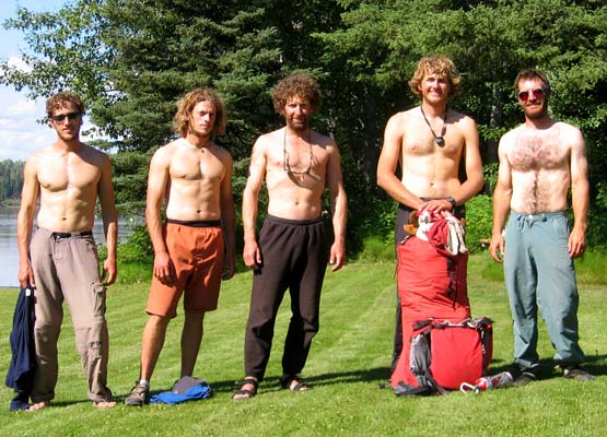
Here is a good time to introduce the cast of characters... Myself, Tom Grundy, paddling the raft "Lotus Flower", not so recently unemployed climbing bum with no fixed address. Craig Clarence, Paddling "Sir Tips-a-lot", Recently unemployed accountant from San Diego. Jason Magness, Paddling "Winnie the Pooh", recently unemployed teacher from San Diego and North Dakota. Andy Magness, paddling "the spirit of Dave", recently unemployed schoolteacher from San Diego and soon to be moving to New Zealand, and finally Daniel Staudigel, paddling "lost and found", recently graduated from high school in San Diego.
 |
|---|
We woke up to the pitter patter of little raindrops. No fun. Craig was the hero who got out and cooked up breakfast (dinner) in a brief lull in the rain. We ate and packed up and got onto the misty river for a long day of paddling. The current was moving along fairly quickly, but there weren't any real rapids, so we made great time. Eventually we saw a group of campers on the bank. They had been flown into Island Lakes, and were waiting for more of their party who had started higher up the river. In keeping with tradition, they had a lot of questions about our rafts and were incredibly nice. When they heard we didn't have any maps of the lower river, they gave us a copy of the guidebook. This turned out to be educational and entertaining when tentbound as well as useful for future river navigation and side trip planning. Then it was on to Moore's Cabin, which was somewhat run down and full of mementos from previous river trips. It was also mosquito infested, so we didn't stay long - yes, mosquitos can bite through wet suits. Next we were looking for Moore's hot springs. After a few false searches up side channels, we found it. There were a lot of interesting tracks by it (like wolf) as well as tropical looking foliage and mosquitos. We wore headnets and wetsuits and just sat down in the hot muddy water. It was nice to warm up, as we were all getting a bit cold. We saw a bunch of wildlife including some moose swimming across the river (the baby moose had trouble climbing the bank), beaver, osprey, eagles... Then on down the river some more to where we eventually camped at the confluence with the Broken Skull River..
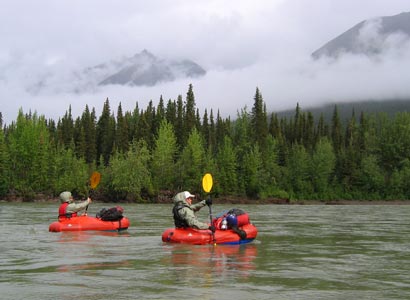
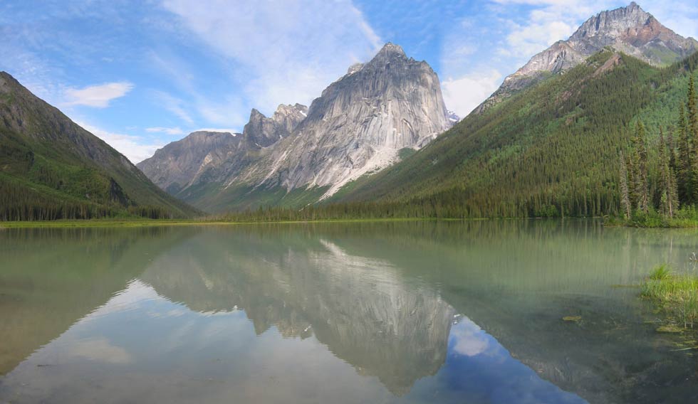
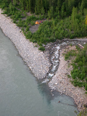
We paddled for a bit, then drifted in the sun a bit before we had to keep our eyes open for the departure point for hiking up to the cirque. We did find the point where the trail left the river and headed cross country, but while I was scouting it, everyone else paddled down to where Britnell creek joined the river. This was a slightly better place to take out and leave our gear, but added a few K to the round trip. We deflated our rafts, packed up the stuff for the cirque and the stuff we could leave. Hung the food we were leaving, and headed off up the buggy trail. It was hot and buggy, one of the worst combinations. The trail was smooth and dry at first, but after we turned inland, it was pretty swampy. Eventually we all gave up on the head nets, as they were too hot, and there were less bugs as we hiked. The trail wasn't very good. I would describe it as easy casual bushwhacking or lousy trail. Luckily every time you thought you must have turned off onto some game trail, you would see another piece of marking tape or a footprint. After a lot longer than we thought, the trail finally came back to Britnell Creek and we were able to get some water. Then we came to a lake, which at first we thought was Glacier lake, but it wasn't. Finally we got to Glacier lake and saw the stashed canoes. Much of the trail was across mossy boggy terrain and I was very glad to be wearing my neoprene sox rather than the one pair of dry sox I had. We took one aluminum canoe along with one homemade paddle (it was a rectangle of plywood nailed onto a stick). Combined with 2 halves of a kayak paddle we loaded 5 of us and gear into the canoe and paddled the 6 K up the lake. This was a lot of work for the paddlers and uncomfortable for those stuck in the middle of the canoe. I was paddling in the stern, and it was hard to keep the canoe going in a straight line as it turned like an aircraft carrier and with 2 other paddlers paddling on various sides, the trim and turning forces were erratic. Just as we neared the end of our paddle, a floatplane dropped into the valley and landed ahead of us. We landed and camped on a small gravel delta made by a stream. We were next to a group of Canadian photographers and people promoting expanding Nahanni National Park. Shortly after we arrived, they paddled over to our side of the delta (to avoid wading across the stream) and gave us their leftover dinner while they sang "Oh Canada". What a great place. Later as we talked about our trip, one sympathetic woman kept putting more and more food into a plastic bag for us. Cheese, juice, cream cheese, pita bread... MMMMM real food. Thanks. The calls of a loon reminded me of my trips in Maine and Quebec.
 |
|---|
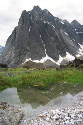
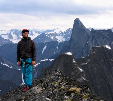
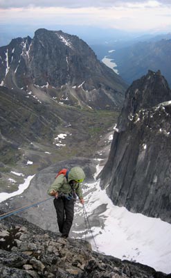
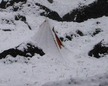
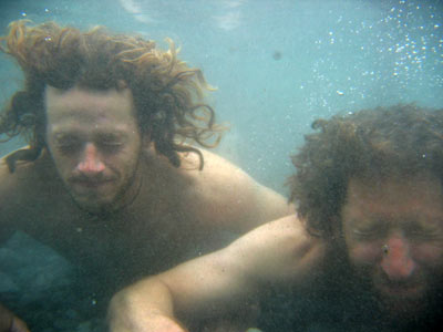
After a breakfast that involved more real food, we prepared for the slog up to the cirque. There was a Swiss group of climbers with an awful lot more gear waiting for a helicopter shuttle and a group of Canadian climbers. At first the trail was fairly straightforward, but then we lost it a few times in downed trees and brush. Then it headed steeply uphill. This didn't seem right, but we couldn't find any other trail. It went up for a ways and then vanished. Rather than head back down the slope and look for a trail like we should have, we started to bushwhack, and it started to rain. We traversed across the slope and downhill across alder and trees and finally got back to the trail after a fair amount of effort. We lost the trail again, but headed up through the woods and talus following goat trails onto the clear talus slope up to the cirque. At a break for a bar, Jason took a misstep off of a boulder and head butted a rock. Immediately he grew a large bloody goose egg above one eye. As we headed up the talus, we could hear and see the helicopter ferrying back and forth from Glacier Lake to the Cirque. We were jealous as we sweated our way up the seemingly endless talus. Eventually we got to the top of the talus and began to traverse around towards the cirque. I was a bit below everyone else, and the helicopter flew by quite low and we waved at each other. Then it circled about and came to a hover beside a large boulder just below me. I clambered and crouched my way down next to it, but had no idea if the guy was telling me something or what, but I figured as long as he was just hovering there, I was hopping in. I goofed and jumped into the back seat, and he zipped up to pick up 2 more from our party. It was a short but exhilarating hop up to the cirque from there. The chopper went back for the rest of our party, while we gawked at the beautiful meadows, lush moss and lichens, and towering peaks. What a way to travel, it would be pretty cool to be able to hop up to alpine playgrounds without the days of slogging it otherwise requires. The view is improved by the suffering though. We talked a bit with the pilot and some of the others up in the meadow before they departed. Then we searched about for a place to set up camp. The 2 prime spots where tents could be pitched under massive boulders were already taken by the Swiss group and a Canadian group, but we found another overhang with some marmot proof food boxes and set up the tents by it. It was then that we made a wonderful discovery, surplus white gas and food left by previous parties. We cooked up a few meals and then did a short sport climb on a boulder near camp. Later that afternoon it rained some more. Craig and I had won the rock toss so we were to get the first shot at LFT. We tried to get an early night, but it is hard when the sun sets so late and it never really gets dark.
 |
|---|
It rained again that night, so we weren't so enthusiastic when we got up at 2:30 am or so. It helped that it wasn't exactly dark, but it wasn't really light either. We grabbed our climbing stuff and made the 1.25 or 1.5 hour hike to the base of the climb. We saw a mtn goat skull on the way. When we got to the base, 2 of the Canadians were leaving in disgust. They had climbed the first pitch the day before, and it was wetter this morning. We took a look at it, and decided to wait for a while in the hopes that things would dry out a little. We put on all our clothes and attempted to sit on the gear and in our packs while waiting for things to warm and dry a bit. Then it started to rain. Luckily this was a brief sprinkle. Eventually things were too cold to sleep, so we hiked across the snowfield and talus to see what the Canadians were doing (a crack further east). Then the sun was almost coming out, and we decided we had to at least give it a try. We got out the ropes and geared up, and then when Craig went up to the base of the climb and was getting showered from the first 3 pitches, we decided to bail. There were 2 ropes fixed on the first 3 pitches. The ropes looked ok, but we couldn't see what they were fastened to or how the tops looked. We took a different route back to camp, but weren't convinced it was a better way to go. We drowned our sorrows in extra food and I finished the book "Snowman", classic pulp fiction from the Magness family library. It rained in the afternoon, and again all night. I boiled up a liter of water for a hot water nalgene bottle "baby" to help keep me warm (the abandoned 3 or 4 gallons of white gas were more than we needed).
It was raining when I got up. Needless to say, the other team didn't head out to climb that morning. I spent the morning reading sections of "My secret life" and the Nahanni Guidebook. We ripped a number of books apart into sections so that more than one person could read at once. By 1 it had stopped raining, and we had some lunch and went for a hike up below mt. Sir James McBrian. The few bits of sunshine were appreciated. There was some fresh snow up on the peaks and most of the walls were wet. The Canadians said that the barometric pressure was up. It clouded up again with a bit of rain in the evening. Craig and I decided to prusik the ropes fixed up the first 3 pitches if it wasn't raining, and that the first 3 pitches probably wouldn't dry the rest of the time we would be there, so we would just have to go for it. (a prusik knot will slide and lock on a rope, and can be used to ascend a fixed rope - known as prusiking)
 |
|---|
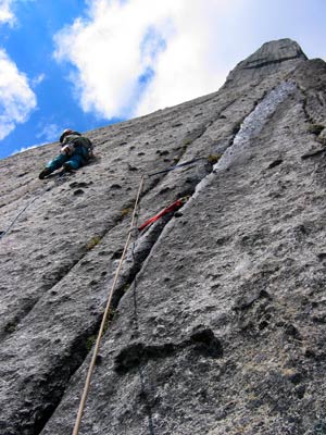
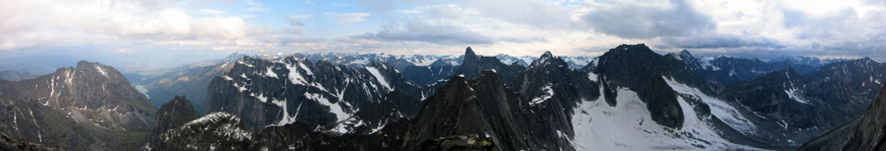
We decided that the recent rain dictated against a super early start, we hoped to get to the top of the fixed ropes after the sun (if there was any) hit the face, so that it could be drier for the free climbing. We got up at 4:30 and headed up to the base. There Craig started prusiking and free climbing. This was a pain on the wet stretchy rope using a prusik knot and Petzl reverso. He was also placing gear in case the rope wasn't strong or wasn't properly anchored. He was able to link pitch one and two. By then I was rather cold, but soon everything but my fingers were warmed up as I climbed up the wet rock. I managed to free pitch one, but then hooked in to the rope with my belay device and used a combination of stemming and hopping and pulling in as much slack as possible on the belay while Craig kept me tight from above. This went fairly quickly, but was exhausting and put a lot of strain on my left hand. Then I got the sharp end, and went up into a drippy waterfall coming from the roof near the top of pitch 3. Eventually I turned the corner onto dry rock and brought Craig up. He was able to pendulum around the corner much lower and avoid some of the wet nastiness. Now we were at the top of the fixed ropes, and had to lead for real. The next pitch would probably have been fairly easy and straightforward when dry, but was sketchy wet. Craig got to lead it, which had me leading the first Chimney pitch. We decided to simul climb as much as we could, so I set off with Craig planning to start climbing when I got to the end of the ropes. Having twin 70 M ropes meant I could really go a long way and still keep a few pieces of gear between us, but since the ropes were a bit wet, they weighed a lot. I had difficulty clipping with one hand, and if I did clip a piece of gear above my waist, it would lift me up for the next few moves but soon I was back to what felt like hauling Craig up the chimneys. It was fairly wet in there, but by mostly staying out near the lip I was able to avoid much of the trickling water. I gradually used up most of my gear and almost all of my slings (to the point that I was threading nuts through fixed piton holes instead of using a sling). Luckily I had just enough pro so that I had gear for the last few moves out of the chimney and up slimy wet cracks to the bivy ledge. The topo says 5.8, but it felt a lot harder and scarier to me, especially when my foot popped off a crystal. I was very glad to get to the bivy ledge and bring Craig up. We had linked the first 10 pitches in 4 pitches and were feeling pretty good. There was even a little bit of sunshine and it was around 12:40. The next pitch was wet, which didn't make Craig happy as he led it. I was able to stem around the wetness and enjoyed it though. Then we were onto the headwall. Mostly we were climbing on knobs and using the thin railroad track cracks for pro. My left hand wasn't feeling very good at this point, but it was still able to pull hard when I needed it to. It looked like we were most of the way up, but the upper pitches went on forever. A helicopter with climbers from Las Vegas circled past us and we hoped that they were able to get some nice photos of us, but from what the others said, they didn't. Craig got the crux pitch. The move over the roof wasn't too bad due to some large holds, but the climbing continued up vertical flaring cracks above. I ended up hanging there to remove some recalcitrant gear. Then a brilliant thin hands crack on the right and a wider crack on the left with a few knobs thrown in to the mix for me, and 2 more linked pitches and a short scramble up to the summit (19 pitches according to the topo). We got there about 8:10. The view was amazing. We ate a celebratory little debbie moon pie and some bars, took a bunch of pictures, looked for a summit register (no luck), and gawked at the views.
 |
|---|
 |
|---|
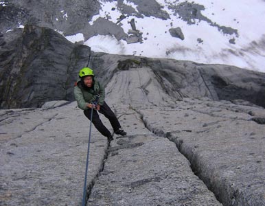
Now came the descent. The topo indicated that the second rappel was a rope sticker, so we did the first 2 raps with just one rope. The 70 M ropes seemed to try to tangle and grab every protrusion and crack on the face both above and below us. Around the 3rd or 4th rap down it started to rain. At first it was just an annoying sprinkle, but then it picked up and the ropes got wet. This made the rap a bit jerkier, and made our hands wet and cold. I miscalculated the length of the rope, and had to build an anchor just above the bivy ledge and wait for Craig to rap to an intermediate anchor. We were glad to get to the ledge, but by then there was a stream runnig down into the chimneys and there was snow mixed with the rain. Also despite the fact that it never really got dark, the dark clouds made it a lot darker than we would have liked. Here the rap route departed from the climb, and we headed off down the face to the east of the chimney. Once again the second rap was supposed to be a rope eater. We managed to get past it ok despite a heart stopping pause in the rope. By now things were getting sort of grim, with our hands turning to claws, the ropes completely soaked (so that water would pour off our hands and belay devices), and visibility greatly reduced (maybe 10-20 feet). The raps seemed to go on forever. At one point I might have missed an anchor, but finally I saw one just before I passed it. Pulling the ropes though, the blue one stuck fast. Normally when a rope gets stuck you at least make an effort to climb up to free it, but we both agreed that this wasn't a good option for us at this point. We tied off the blue rope and hoped that with the 90 or 100 meters of rope available we could hit the top of the 3rd pitch and the fixed ropes.
 |
|---|
 |
|---|
 |
|---|
 |
|---|
The next morning everything was covered with snow and it was still coming down. I pretty much stayed in the tent 'til after noon reading and trying to sleep. When I got out for some food, I spent some time trying to dry out my insulation. (I got the sleeves of my puff jacket to steam by putting a hot water bottle in them). The Canadians came over to ask us about the climb and tell us that the barometer was as high as it had been so far. Since it was still snowing, I didn't believe it was such a great sign, although I did think maybe it would clear up and be bitter cold. Instead it kept snowing. We pretty much came out only for food. Unlike some of the other groups, we didn't have heavy winter boots or enough warm clothes to risk getting some of them wetter. I was able to dry my insulation by warming it with hot water bottles and wearing it damp in my sleeping bag.
Once again, it was snowing when I woke up, so I didn't get up. I read more, and slept more, and just stared at the tent in a semi-vegetative state. By 11 the precipitation was slacking off, and we decided to bail. We had a few more days of food before we had to leave the cirque, but with the continued bad weather, the other team thought their chances were pretty slim of getting a decent shot at the climb. Everyone was pretty sick of being cold and wet, and all of the extra food was gone. So, we packed up all our cold wet stuff and headed down the hill. Just as we left the Swiss camp, it looked like the sun might break through, but it didn't. Soon after leaving the cirque, we passed out of the snow. As we went down the talus, we saw a number of groups hiking up including some of the canoeists who had given us the guidebook and some other climbers. Hopefully they had better luck with the weather. At the bottom of the talus, Craig and I thrashed around 'til we found the trail back, while the adventure racers headed out to Britnell creek and headed down that (with a few waist deep crossings). They got back before us, but possibly only because when they came out at the end of the creek, there was a guy in a canoe who paddled over and picked them up so they didn't have to wade around or swim across. Then we got a decent canoe with a real paddle overloaded with 5 people and packs and paddled back down Glacier Lake. From there we had an even wetter hike back to our boats. It was like hiking on a giant moss sponge. There was a large group camped where we had stashed the rafts. As usual, they were very curious about our pack rafts, and gave us some leftover dinner. By now it was around 9 p.m. but the sun was out. We headed off down the river and paddled to the end of the rabbitkettle lake portage. There we stashed our boats on top of a bear platform and hiked the 1.2 miles into the campground. I think we finished dinner and were in bed after midnight. A long day (at least the part after 11 am). It started raining again after we were in the tents.
Despite plenty of rain, things were relatively dry when we finally got up. A hot breakfast later and we were ready to sign into the park and head off down the river. We saw a bear (it looked like a grizzly but was pretty far away) swimming across the river. We stopped to burn some trash on a gravel bar with a plentiful supply of driftwood, then on down the river, 55K total. We camped on a gravel bar. Looking back towards the cirque, it looked stormy all day. That night it rained off and on, making a mockery of my attempts to dry things out.
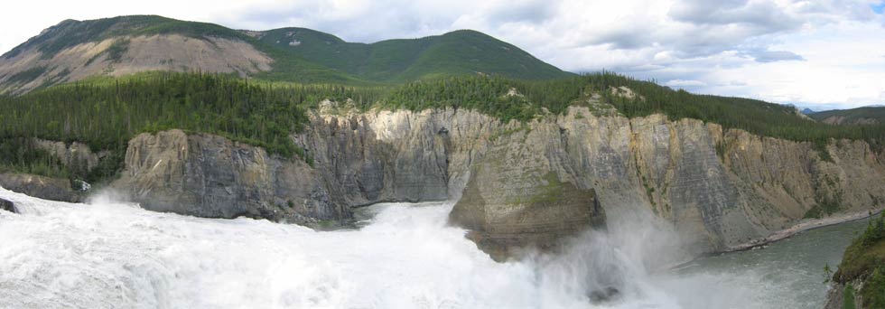
We knew this was going to be a long day of paddling, on relatively flat water, so we got a relatively early start and a hot breakfast. At first we were making really good time as the water was flowing fairly fast. Then as we got more and more tired, the current slowed down and the river was making huge meander loops. Luckily we didn't get a bad headwind. We finally got to the virginia falls campground. There were docks and boardwalks everywhere. It was like a slice of civilization in the middle of nowhere. We signed in, set up our tents, put stuff out to dry, and I patched the floor of my raft. (It had been sliced by a sharp slate outcrop while eddying out of a rapid on the little Nahanni). I patched it with duct tape so my raft didn't slowly fill with water, but now I had a chance for a more permanent patch). Then we went down the boardwalk to check out the sluicebox rapid and Virginia falls. The extent of the boardwalks here were pretty amazing. The river was fairly wide and slow and then it went down in huge tongue into the sluicebox rapid, which started out only huge, and then got a lot bigger. After a lot of huge waves and boiling and exploding water, it leaped over the edge of the falls, and plummeted some 90 meters into 4th canyon (the canyons were named by explorers heading up the river, so 4th canyon comes first when heading downstream). We were impressed by the falls and rapids and took lots of pictures and ate lots of blueberries. We even took a small trail down onto an outcrop just above the lip of the falls (where the group picture was taken). As we headed back, it started to rain, so there was a bit of a rush to get back and pack up everything before it got wet again. Then we headed to the program area and saw a presentation on Dene (Native population) clothing and decoration. It rained pretty hard near the start of this. That night a brown bear was up on the boardwalk investigating our bowls and making a bit of noise, he left as soon as we unzipped the tents. We moved the stuff that might have been attractive up onto the bear platform (the food was already there).
 |
|---|
 |
|---|
We had decided to spend the next night camped here too, so we slept in a bit and had a leisurely morning. Then we borrowed a canoe from an outfitter and paddled across the river to hike up sunblood mountain. I was still feeling a little tired from the climbing day I think, but the others zipped ahead while I was getting a drink and taking a picture. I caught up with Craig eventually while he ate a bar. He said the others went into adventure racing mode and were pretty much running up the mountain. We could see that a storm was brewing to the northwest and headed our way. We passed a number of people heading down as we headed up the last bit. Then finally we got up to the summit just as the first drops hit. Visibility was dropping fast, and there wasn't much point in taking any panoramic shots. We pretty much just put on our raingear and headed back down. It really poured for a while, but had stopped by the time we got all the way down. We paddled back across for some hot lunch and to crawl into the tents when it started raining. I read "Monster from Earth's End", a particularly egregious bit of pulp from 1959. It rained off and on for the rest of the afternoon. The program that night was on Dene foods, with samples of various delicious berry jams and bannock. MMMM that hit our sweet bread cravings nicely. We also got some leftover dinner from one of the guided groups. After the program, we got a fire going and stood around it well into the evening.
 |
|---|
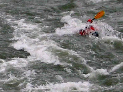
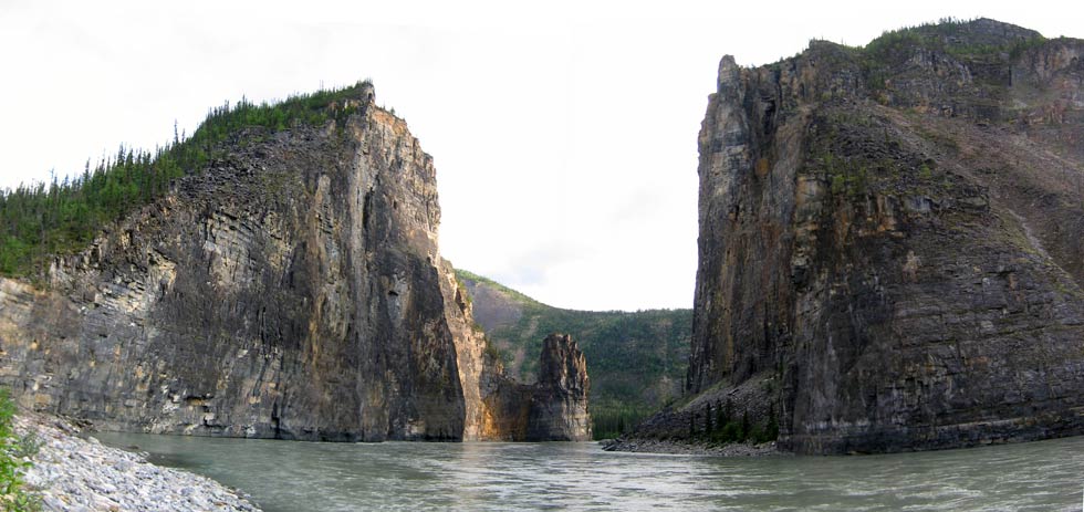
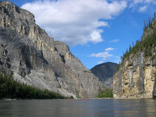
Once again, it rained during the night. We packed up our gear and made the portage in one trip. We marvelled at the mostly boardwalked portage trail and the piles of gear some of the other groups had (of course they were living in luxury compared to us, and we were very glad to get their leftover food). Still, it was nice to just take a single load over the trail. Then we inflated our rafts, hiked up closer to the base of the falls for a look, and set off down 4th canyon. What a fun way to travel. We were carried along through spectacular scenery on a roller coaster conveyor belt with enough waves to make things exciting, but not enough to really soak us or to make things scary. Eventually, we got to figure 8 rapid (AKA hell's gate). This had the potential to be the biggest rapid on the S Nahanni that we would run, however the river had recently taken out part of the gravel bar which decreased the severity of the rapid. We scouted it and ate blueberries. We decided to try to get some pictures of this rapid, so set up with the camera while we took turns going through the rapid. The first part had some huge boils and whirlpools, and the end had some big standing waves. It looked like you could totally sneak the rapid in a canoe now, as where it used to really pile up against the wall, there was fairly clear water. So, we took turns running the rapid and taking pictures. I nearly flipped twice in the early section when a whirlpool suddenly yawned beside me. Some hard paddling and bracing kept me out, but I thought I was a goner for a second. Then I nearly flipped again at the end when I thought it was all over and got complacent about the eddy line. Last up was Jason, who did get sucked into a whirlpool. He said his raft got stood up and water was pouring in the back and both sides before he finally flipped. Unfortunately, we weren't taking pictures of his position, and missed it all. That put him into the lead with 5 flips, but Andy wasn't going to let his brother beat him. In the next rapid, that we could have easily avoided, all of us but Craig plowed through the middle of it into the "funny water", and Andy suddenly stopped going forward at one point despite still paddling like mad. Then he flipped. I also had a point where I felt the river sucking me back, but by leaning forward and trippling my paddling rate, I managed to escape the same fate. There may be something to Jason and Andy's claims that they flipped more often because they were in smaller boats. Then we paddled on down through scenic third canyon to the gate. This was very reminiscent of the gates of Argonath from the Lord of the Rings. The river took a 90 degree turn to the right and cut through towering cliffs. We set up at a beautiful camp here, and after dinner hiked up the left side of the gate where you could look down a few hundred meters to the water below. A tossed rock provided a lot of amusement and took about 5 seconds before it crashed into the water. That night it didn't rain! For the first time in the trip we went over 20 hours without precipitation.
 |
|---|
 |
|---|
The weather seemed a lot warmer today, and we thought maybe things had finally changed. We paddled through the gate into second canyon and eddied out on the far side. There we hiked up to the base of pulpit rock. It looked pretty climbable, but was too chossy for my tastes. Jason and Andy headed up for a recon and ended up on the summit where they found an old cairn. Then we loaded up and headed on down past acres of Limestone, shale, and sandstone walls towering above us. The end of the canyon brought anastomosing channels in a broad valley. I had to climb a ladder up the eroding bank to get to the cabin to sign our group in. It too was filled with momentos of people's trips down the river - mainly tiny carved paddles hanging from the rafters. We camped on a gravel plain at below dry canyon. Just upstream was a particularly good place for tracks. I saw grizzly, dall sheep, moose, beaver, wolf, raven?, and human tracks here. There was just enough rain so that it had still rained every day, but not enough to actually get anything particularly wet. That night, someone threw a rock into the water and a fish jumped. Despite many more attempts, we only managed to repeat this about 4 times, although it was most impressive when they were demonstrating it to me, and it actually worked again.
 |
|---|
This was a day to recover and rest... and rock climb. We set up one top rope at the mouth of dry canyon. It looked a bit chossy, but in reality it was horribly chossy. I was tiptoeing my way up, and still kicking off chunks, and when it got steeper, I was scared I'd pull off whole sections. We wisely moved the rope a bit further up the canyon onto more sound rock. There we took turns heading up what was about a 10d or 11a line. We also hiked up into dry canyon to gape at the massive limestone cliffs and fossils (mostly coral). Craig was back at camp when the raft went by and dropped off a load of sandwich makings including much appreciated lettuce. Once again the friendly Canadians keep THE HUNGER at bay. By the time we all got back to camp, there was a black thunderstorm building but it mostly skirted by us. Then we packed up and headed down river into first canyon. There we went through George's Riffle, a rapid that had a number of large standing waves combined with weird waves bouncing off the walls that came from the sides and interfered or reinforced the standing waves in weird ways. I tried to eddy out immediately to get some pictures with only moderate success as I was shooting into the sun. Almost immediately after we got through the rapid a huge headwind blew up. The water drops were shooting sideways off our paddles, and we were only making moderate headway down the river despite a very strong current. This was pretty frustrating, but at least it hadn't hit us on one of the stretches of flat water. Eventually things clouded up and the wind backed off a bit. The cliffs here were quite spectacular, and often banded. There were caves high up the canyon walls, and according to the guidebook we were passing through a large karst plateau. We pulled over at the spectacular white spray springs to fill our water bottles with ice cold crystal clear water. It gushed out up through the talus and into the silty river. A few K later we pulled out at the mouth to Lafferty Creek just as it started to rain. We quickly set up the tents and cooked and ate dinner during a lull. Then when the next round of rain hit, we retreated to the tents for reading and sleeping. It rained off and on all night.
 |
|---|
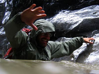
When we woke up, it was still raining. It was still sprinkling when we couldn't take it any more and got out to hike up Lafferty Creek. The rain stopped shortly after we started hiking, but that didn't matter much, as soon we were wading, and then finally swimming up through the short section of slot canyon. Before I started wading, I cleverly put everything but my footwear and rainclothes into my dry bag / backpack for safekeeping. Then we hiked up the canyon a fair ways 'til we saw a cave mouth up on one of the cliffsides. Jason was convinced we could scramble up to it, but I had my doubts. We went up a talus slope and were confronted with a steep wet slab. We headed back to camp. We got onto the river shortly before 5 pm. There was one last rapid, Lafferty's Riffle. Craig said he'd give Daniel a bag of m&ms if he went through the rapid sidesaddle (both feet sticking out on one side of his pack), especially if he dumped. He nearly did dump, but made it. This rapid was another one with big standing waves along with waves bouncing off the wall. It would have been possible to totally avoid it on the left, but what is the fun in that? I was trying to take pictures, and got turned around backwards and nearly dumped as the waves got bigger. I had to throw down the camera and start paddling. After Lafferty's, it was only a short paddle to Kraus' hot spring where the raft we had been leapfrogging was also camped. There was a nice pool on the riverbank, and other than the revolting stench of rotten eggs, it was nearly perfect. We all soaked for a while. Then we attempted to dry some of our stuff out, cooked up dinner. A canoe group pulled in and soaked a bit before paddling further down the river. We retreated to our tents as the mosquito density picked up. I finished "Stone 588", the last of our books.
 |
|---|
We knew this would be a long day, so we got up around 6:30 and had a hot breakfast. Then we paddled off into the mist down the river. Soon the valley opened up again, and the river channel was going all over the place (known as the splits). In a few places one group would go one way, and others another. Depending on the speed and orientation of the channels, that could put the group that picked the wrong channel hundreds of meters behind the other, which would float and lily dip while the group in the back would paddle to catch up. I lost my spoon when it popped out of my bag with a bar, and slowly sank into the silty river (yes, lexan does sink). At first between our paddling and the current we were making excellent time (around 15K an hour at best), but as the sun came out and things heated up, the river went slower and slower. We hoped to avoid a huge meander by carrying our rafts across a small neck. However we did this at the wrong place and wasted a bit of time. Then we were into the huge meanders (5K or more in length). It seemed like we were paddling the wrong direction for ages. Finally we were onto the last long straightaway, and Andy decided to paddle a lot faster. Of course we all had to try to keep up... After what seemed a lot longer than it should have (we were all spoiled by the fast current higher up the river), we got around the corner to Nahanni Butte. There was a camping area a little out of town and we pulled off there. Holy mosquito clouds. They were pretty thick here. We set up our tents and set stuff out to dry and headed up the dirt road to Nahanni Butte. The people there must be fairly used to oddly dressed smelly boaters wandering through town, as they pretty much ignored us. We were amazed that some of them were wearing t-shirts, while we were bundled up and wearing headnets. Luckily for us, the general store was open 7-9, and we were just a few minutes early. Andy was psyched to get coffee, Craig a cold pepsi, and we all sat in the lounge? out of the bugs and watched the satellite TV (worlds strongest man competition from Russia, News, some inane reality TV...) then back to camp to burn some more trash and Monster from another World, eat dinner (I finished my olive oil and peanuts), and most importantly, get out of the bugs.
 |
|---|
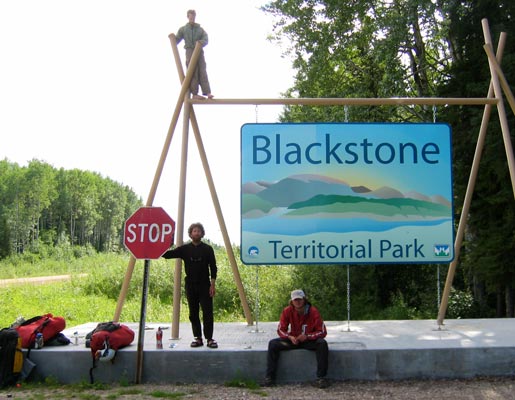
After a poor nights sleep, we packed up and headed off down the river. The confluence with the Liard was marked by a line of scum and a distinctive reddish brown Liard with a darker silty Nahanni slowly disappearing into it over the course of a few K. The Liard was moving along at a few K an hour, but was so wide that in the middle it seemed like we were barely moving. There were a few Bison on the sandbars presumably out there for the better visibility and less bugs. Then we took a "short cut" thin channel to avoid a large meander. I don't know if it saved us any time. Eventually we approached what we thought was Blackstone Landing at a bend in the river. As we began to get closer, we realized that the current was pretty strong along the bank, and we all ended up a bit downstream. We paddled up along the bank or waded up to the little dock. Then we hauled our boats out and began to pack things up. This took longer than usual, as we were trying to dry things out a little before packing them up. We signed out and hiked to the main road to try out our thumbs. The river phase of the trip was over, but we still had a long way to go to get my truck back and get back to the States. We didn't have much luck with our thumbs, as among other things, it seemed like every car pulled into Blackstone Landing. Jason hitched over to Lindberg Landing and found out that the women from the raft we had seen nearly every day were going to be driving our way tomorrow morning and would have room for 2 of us. Well, that seemed like a long way off, but at least it was a start. Around 9 pm, Jason, Daniel, and Andy headed off down the road hiking. Craig and I stuck around at the intersection. A guy who had been out jogging drove back out to give us some food (gotta love these Canadians), and Craig said the other 3 were probably pretty hurting too. We figured they were pretty psyched to have someone drive up and hand them some food. Finally around 11:30, after hearing about a very drunk native who had been by earlier roll his truck, we totally gave up and went to sleep for the night.
 |
|---|
I got up early and moved out to the intersection in case the women were getting an early start. We REALLY didn't want to miss them. It was misty, and a ghostly sun rose above the silhouetted pine trees. Best of all, it was cold enough that there weren't any mosquitos out. Eventually the mosquitos picked up, and I managed to armor myself in my sleeping bag and headnet. We gradually packed up and tried to dry the tent as the morning progressed. Craig walked to the little visitor center when it opened and grabbed us both a cup of coffee. The women showed up at 10, a little later than they planned due to a low tire. We piled in and were off down the road. We kept our eyes open for the other three to at least give them the last of our food, but we never saw them. We stopped at Ft. Liard to check out the native crafts store there. There was some fabulous work, but the prices were out of my range. On to the Fort Nelson visitor center where we were glad to see familiar packs ad helmets jammed under the benches. The person there gave us a rather extensive list of places they might be, and we headed off to find them. No luck at the library, but at the laundromat, there they were in a motley collection of cast off clothes from the free bin. Andy in a vest and sportcoat, Jason in a fitted (women's?) shirt and skirt, and Daniel in some old school adidas sweats and a hoody. Unfortunately I didn't have the camera with me.
We heard how the others had covered some ground hiking, and a very drunk native had offered them a ride (they wisely said only if we drive) (Craig and I had come to the same conclusion, but he didn't offer us a ride when he headed back out of the park). A few K further down the road, he rolled the truck. By the time They got up to the scene, the people from the truck had been hustled into other vehicles and driven away. Finally around 1 am, while they stumbled down the middle of the road fueled by a handful of gorp every half hour, a truck came along that gave them a ride all the way to Fort Nelson.
There were some issues with the car rental place, as it was based out of a gas station, and the kid working the gas station wasn't able to rent cars. A number of phone calls later, I was waiting at the gas station in case the woman showed up, while the other's checked e-mail and ran other errands. She showed up shortly, and we were in business. Unfortunately, the only rentals in Fort Nelson charged .20/K. It was going to be an expensive 24 hours. Andy, Daniel, and I loaded up and drove on up the road back to Watson lake. On the way we saw a lot of caribou and had to stop to let some bison meander across the road. Boy are they big. Once again, I wish I had my camera with me. In Watson lake we had to buy a gas can, as my truck was more than 1/2 empty. We also got 2 liters of mountain dew for the caffeine and sugar. We finally got to my truck around 1 am. I was glad to see it, and I briefly checked the tires and under the hood for obvious problems. Then I went to start it and nothing happened. I was getting a little worried, when I remembered the kill key. phew. Then I drank my can of some nasty energy drink, and we headed back. Jason went back to the rental car to sleep after we got past the worst of the bumps, and I was frustrated to find that Andy had finished off the mountain dew. Oh well. I drove the rest of the way to Watson lake, then crawled into the back to sleep for a few hours. I took the wheel again and we drove in to Fort Nelson around 1 pm. There we loaded up the truck, returned the car, and headed to Prince George. We dropped Craig off there around midnight, and continued south in the first dark night we had seen in a long while. We stopped in the morning at Hell's gate to try to look at the rapid, but it was a longer hike than we thought to a good viewpoint, so we headed on, arriving in Seattle before noon. Then I drove to SeaTac to drop off Daniel, and the trip was officially over (although I still had to drive down to Portland before I could get my much needed shower).
I would like to thank some of the people and products that made this trip possible. First of all, my companions on this trip made it all happen, and while sometimes it seemed you would do something specifically to annoy me, I am glad I got a chance to go on this trip with all of you. Also, thank you to the various relatives and significant other's of the team members for letting us go on this hare-brained trip and covering for us on the home front. Next up is Outdoor Research, your jackets and drybags were used every day of the trip. We couldn't have done this trip the way we did without Alpacka pack rafts. They worked well, and everyone who saw them was intrigued. We should have taken a bunch of waterproof Alpacka business cards with us. The final thanks go to Go-lite, Montbell, and Liberty Mountain.
 |
|---|